


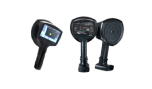

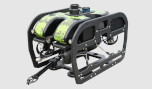

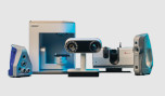
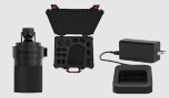

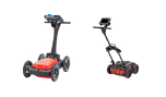
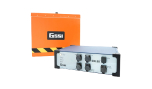
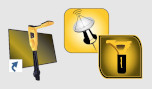


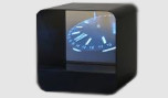
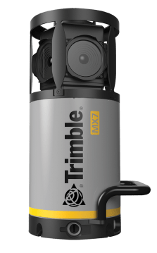
Trimble MX7
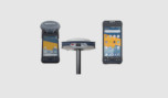
Εύκολο σύστημα λήψης εικόνας για φορητές συσκευές.
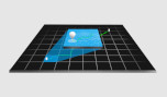
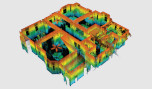
Ο Trimble® MX7 mobile mapping system της Trimble διευκολύνει την ομάδα σας στη διαχείριση των περιουσιακών στοιχείων. Συλλέξτε εικόνες 360 μοιρών στο πεδίο και, στη συνέχεια, εξάγετε και αναλύστε δεδομένα εικόνων στο γραφείο. Καλώς ήρθατε στον κόσμο της κινητικής απεικόνισης.
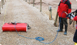
Χρησιμοποιήστε το Trimble MX7 και συλλέξτε εικόνες 360 μοιρών με γεωαναφορά σε ταχύτητες αυτοκινητόδρομου. Έτσι, μειώνετε σημαντικά το λειτουργικό κόστος του έργου σας βελτιώνοντας παράλληλα τη δημόσια ασφάλεια. Με το λογισμικό Trimble MX μπορείτε να οργανώσετε, να οπτικοποιήσετε και να εξάγετε δεδομένα που μπορούν να ενσωματωθούν σε ένα GIS και κοινοποιείστε τα.
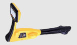
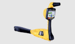
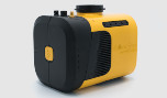
Το σύστημα απεικόνισης Trimble MX7 Mobile Mapping Imaging είναι ένας γρήγορος και οικονομικά αποδοτικός τρόπος διαχείρισης στοιχείων όπως γέφυρες, κτίρια, δρόμοι, αυτοκινητόδρομοι και σταθμοί παραγωγής ενέργειας, καθώς και η τεκμηρίωση των συνθηκών τοποθεσίας με εικόνες με γεωγραφική αναφορά.
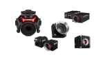
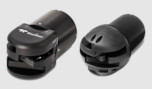
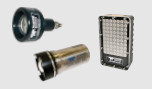
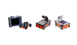
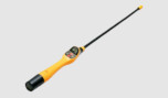
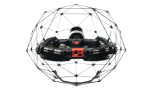
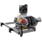
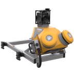
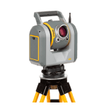
Το Trimble MX7 με τεχνολογία VISION™ είναι ένα φωτογραμμετρικό σύστημα τοποθετημένο στο όχημα εξοπλισμένο με κάμερες έξι, 5 megapixel και Trimble Applanix GNSS και μονάδες αδρανειακής γεωαναφοράς. Το Trimble MX7 μπορεί να αναπτυχθεί σε οχήματα όλων των μεγεθών, επιτρέποντάς σας να τραβήξετε εικόνες 30 MP με γεωγραφική αναφορά σε ταχύτητες αυτοκινητόδρομου.
- Γρήγορη τεκμηρίωση εικόνων με γεωαναφορά 360 μοιρών
- Τοποθέτηση ακριβείας με χρήση GNSS και σύστημα αδρανειακής αναφοράς
- Εφαρμόζεται σε όλα τα μεγέθη οχημάτων
- Ανθεκτική, αξιόπιστη και ελαφριά σχεδίαση με χαμηλή κατανάλωση ενέργειας
- Χρησιμοποιήστε το με το διαισθητικό λογισμικό Trimble Mobile Imaging Capture
Το Trimble MX7 καταγράφει γρήγορα και με ασφάλεια περιβαλλοντικά δεδομένα δρόμου, υποδομής και πόλης σε στατικές ή κινητές θέσεις, έως και ταχύτητες αυτοκινητόδρομου. Το Trimble MX7 mobile imaging για διαχείριση στοιχείων, προσφέρει:
- Ανάλυση:
30 MP (5 MP x 6 CMOS sensor) - Οπτικό πεδίο:
90% of full sphere - Βάρος:
11.3 kg - Θερμοκρασία λειτουργίας:
0 °C έως +35 °C - Βαθμός προστασίας IP (μονάδα αισθητήρα):
IP65 - Υποσύστημα εντοπισμού θέσης:
Ενσωματωμένο Trimble GNSS-αδρανειακό σύστημα
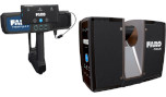
Λογισμικό
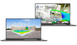
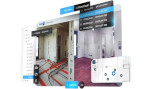
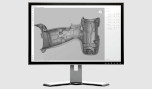
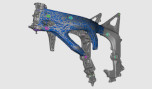
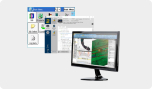
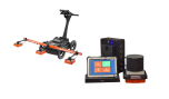
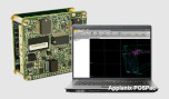
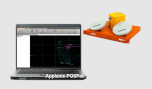
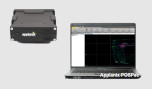
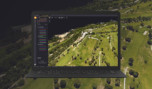
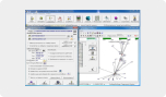
- Το Trimble MX7 σάς επιτρέπει να παρατηρείτε οπτικά και να αποτυπώνετε την τοποθεσία εργασίας και στη συνέχεια να παράγετε παραδοτέα στο γραφείο αργότερα χρησιμοποιώντας το λογισμικό Trimble Trident και Applanix POSPac™ MMS. Το λογισμικό Trident Imaging Hub είναι διαθέσιμο με το σύστημα και προσφέρει ισχυρή τοποθέτηση αντικειμένων, μέτρηση, δημιουργία επιπέδου δεδομένων, τρισδιάστατα μοντέλα και ανάλυση γεωγραφικής αναφοράς
Εφαρμογές
- Τοπική αυτοδιοίκηση: απογραφή και διαχείριση περιουσιακών στοιχείων, μοντέλα πόλεων
- Εξόρυξη: κατασκευή, παρακολούθηση
- Πετρέλαιο και φυσικό αέριο: παρακολούθηση τοποθεσίας, παρακολούθηση περιουσιακών στοιχείων, ανίχνευση αλλαγών
- Βοηθητικά προγράμματα: ηλεκτρικό, σωληνώσεις
- Χαρτογράφηση μεγάλης κλίμακας
- Δρόμοι: έρευνες κατάστασης, οπτικοποίηση, συντήρηση
Χαρακτηριστικά
Παρακάτω, θα βρείτε τα κύρια χαρακτηριστικά του προϊόντος.
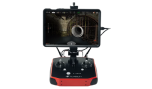
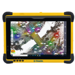
Μέσω υπολογιστή ή tablet με δυνατότητα WiFi
Χρησιμοποιήστε το εύχρηστο, διαισθητικό λογισμικό Trimble MX για να ρυθμίσετε τις παραμέτρους του συστήματος, να διαχειριστείτε την εγγραφή δεδομένων και να σχεδιάσετε το έργο σας.
Ιδανικό για νέους
Εάν είστε νέος στη χαρτογράφηση για φορητές συσκευές, το Trimble MX7 είναι η καλύτερη φορητή συσκευή απεικόνισης για εσάς. Συλλέξτε πανοραμικά πεδία και, στη συνέχεια, ολοκληρώστε τις ροές εργασιών διαχείρισης στοιχείων.
Συλλέγοντας τις καλύτερες εικόνες
Το MX7 συνοδεύεται από έξι ξεχωριστούς αισθητήρες CMOS 5 megapixel και ένα Trimble Applanix GNSS και σύστημα αδρανειακής γεωαναφοράς.
Κάντε περισσότερα με το λογισμικό Trimble MX
Το προαιρετικά περιλαμβανόμενο λογισμικό γραφείου σάς επιτρέπει να εξάγετε, να αναλύετε και να μετράτε τις εικόνες που έχετε συλλέξει στο πεδίο και, στη συνέχεια, να τις δημοσιεύετε στο διαδίκτυο.
Ποικίλες εφαρμογές
Η Trimble μετατρέπει τα δεδομένα σε πραγματική νοημοσύνη χρησιμοποιώντας την πιο προοδευτική, αξιόπιστη και ακριβή τεχνολογία ακριβείας για την κάλυψη των αναγκών ποικίλων εφαρμογών.
Το μέλλον της εργασίας σας
Η Trimble διευκολύνει τις υψηλής ποιότητας, παραγωγικές ροές εργασίας και την ανταλλαγή δεδομένων, αυξάνοντας την αξία για μια παγκόσμια, ποικιλόμορφη βάση χρηστών.
Πολυμέσα
Παρακάτω θα βρείτε όλα τα διαθέσιμα πολυμέσα, συμπεριλαμβανομένων βίντεο & εικόνων.
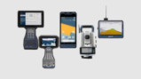
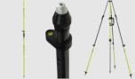
Σχετικά προϊόντα
Δείτε σχετικά προϊόντα από αυτόν τον κατασκευαστή
Ζητήστε προσφορά
Μπορείτε να συμπληρώσετε την παρακάτω φόρμα επικοινωνίας και ένας από τους εκπροσώπους μας θα επικοινωνήσει μαζί σας σύντομα.