


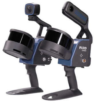
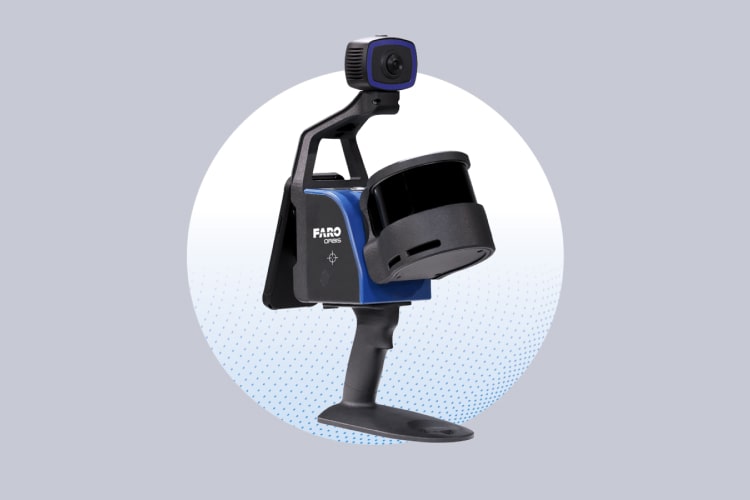
FARO Orbis Mobile Laser Scanner
Powered by GeoSLAM
Experience the power of speed, precision, and flexibility with the FARO Orbis. This cutting-edge mobile scanning solution, by FARO, powered by Flash Technology, is built to perform. With its rugged IP54 rating and upgraded high-performance camera, the Orbis Premium captures ultra-high-resolution images and vibrant, color-rich point clouds—delivering stunning 72MP scans with unmatched clarity and detail.
Unlock next-level productivity with the FARO Orbis range — powerful, mobile scanning solutions built to streamline your workflow and supercharge efficiency.
Whether you’re in surveying and mapping, engineering and construction, or public safety, Orbis empowers professionals with lightning-fast capture speeds and incredibly precise 3D visualizations of the real world. With FARO’s innovative Flash Technology™, stationary scans take just 15 seconds, delivering exceptional detail from a truly mobile platform.
Orbis Premium pushes boundaries even further with a rugged IP54 rating and a high-performance camera that captures vivid, high-resolution images for stunning point cloud colorization — making it the ideal solution for demanding environments where accuracy and durability are essential.
Powered by GeoSLAM’s industry-proven SLAM algorithm, Orbis and Orbis Premium redefine what mobile scanning can achieve. Deliver highly accurate results faster, minimize user fatigue, and boost project efficiency like never before.
Take your scanning to the next level with Flash Technology™, seamlessly connected through FARO Sphere® XG for in-field cloud syncing — and transform the way you capture reality. Orbis and Orbis Premium: your go-to partners for today’s toughest scanning challenges.
Business Value of FARO Orbis
- Revolutionary Flash Technology™ & 72MP Camera Quality
Elevate your mobile scanning experience with FARO’s breakthrough Flash Technology™, now available in both mobile and stationary modes. Orbis and Orbis Premium capture high-density, ultra-accurate datasets with unmatched clarity. Embedded Flash scans can be triggered as often as needed—delivering a powerful combination of speed, detail, and precision within a single, all-in-one solution. - Capture Data 10x Faster Than Traditional Methods
Say goodbye to time-consuming setups. Orbis is designed for rapid deployment, delivering survey-grade accuracy up to 10x faster than conventional laser scanning. Whether you’re scanning a construction site or mapping a complex structure, Orbis dramatically accelerates workflows and keeps your projects ahead of schedule. - Frequent, High-Quality Data for Smarter Decisions
Gain a competitive edge with more frequent, real-time 3D data collection. The Orbis platform supports agile data capture—perfect for dynamic environments or evolving project needs. Combined with cloud integration via FARO Sphere® XG, Orbis makes it easy to generate fresh insights, collaborate seamlessly, and respond faster—especially in time-critical sectors like public safety. - Scanning Made Simple
Scanning shouldn’t slow you down. Orbis is built for ease of use, enabling anyone to capture accurate data with just the push of a button and a walk through the site. With minimal training required, it empowers teams across industries to scan in places previously unreachable or impractical, making complex surveying accessible to more professionals than ever. - Powered by the World’s Leading SLAM Algorithm
Under the hood, Orbis runs on a decade-honed SLAM algorithm trusted in some of the world’s harshest environments. Continuously refined through real-world feedback, it delivers robust, reliable results across industries—giving you confidence in your data, no matter the conditions.
FARO Orbis Features
- Built for the Toughest Conditions
From underground mines to dense forests, crime scenes to active construction sites—Orbis thrives in the most challenging environments, even complete darkness. It’s engineered to perform where other scanners fall short. - A Truly All-in-One Mapping Solution
Adapt to any environment with a flexible system designed for mobility. Use Orbis with a monopod for stationary Flash scans, vehicle mounts for large-area coverage, backpacks for rugged terrain, or cradles for vertical access into hazardous spaces. It’s the ultimate go-anywhere solution.
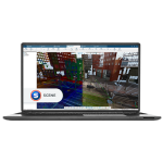
Note: Colorized scans may vary in low-light conditions. - Merge & Sync Seamlessly with Sphere XG
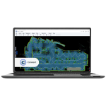
Unify multiple scans into a single, comprehensive project. FARO Sphere XG and FARO Connect offer bi-directional sync, allowing users to merge, align, and update point cloud data effortlessly—all while enjoying enhanced viewing and accessibility features. - Next-Level Visuals with a 72MP Camera
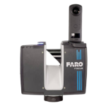
Orbis Premium takes mobile scanning to the next level with a powerful 72MP panoramic camera, delivering vibrant, photo-realistic imagery and colorized point clouds. Get greater detail, better context, and more confidence in your analysis. - Smarter Data Management with Advanced Logging
Experience faster, more reliable data handling thanks to Orbis Premium’s upgraded internal data logger. This enhancement ensures smoother performance, real-time processing, and more dependable results—no matter the complexity of your project.
Features
Below, you will find the main features of the product.
Ideal for Indoor and Outdoor Mapping
With an impressive range of up to 120 meters, Orbis is designed to handle both indoor and outdoor environments—seamlessly transitioning between spaces for versatile and uninterrupted scanning.
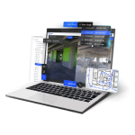
Flexible On-Premise or Cloud Processing
Choose the best-fit workflow for your team with offline processing via FARO Connect or optional cloud-based analysis in Sphere XG—ideal for managing and sharing sensitive project data.
High Accuracy in Every Scan
Achieve up to 5mm precision during mobile scans and as fine as 2mm in Flash stationary scans—offering the reliability and detail needed for the most demanding scanning tasks.
Vivid Colorized Data and 360° Imagery
Capture panoramic 360° photos and rich, colorized point clouds with the integrated high-resolution camera—delivering vivid, context-rich datasets for deeper insights.
Built for Rugged Environments (IP54)
Rated IP54 for dust and water resistance, Orbis Premium delivers reliable, accurate performance in harsh conditions—perfect for job sites where durability is critical.
Portable, Lightweight Design
At just 3.6kg including the datalogger and battery, Orbis is light enough for extended use while scanning large areas—no bulky equipment or complex setup required.
Applications
Discover the applications in which the product can be used.
Agile Scanning for Disaster Response and Recovery
Speed Meets Precision for Surveying and Mapping
Smarter Scanning for Safer Mining Operations
Track Progress and Collaborate in Real Time
Security Planning with Confidence and Clarity
Fast, Detailed Documentation for Crime and Crash Scenes
Testimonials
Read what our satisfied customers have to say.
Related Products
See related products from this manufacturer
Get a Quote
You can fill out the contact form below and one of our representatives will contact you shortly.