GeoSLAM ZEB Horizon RT
Mobile Scanner
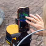
Discover a versatile tool, by FARO, that lets you capture, process, and understand your environment with instant, real-time feedback. Powered by GeoSLAM’s cutting-edge, constantly evolving SLAM algorithm, the GeoSLAM ZEB Horizon RT is the go-to solution for surveying pros who demand faster results and greater efficiency. Whether handheld or mounted on a drone, car, cradle, pole, or backpack, it adapts effortlessly to any mission.
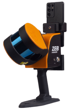
The ZEB Horizon RT is a powerful, adaptable mobile LiDAR scanner built to tackle both outdoor and indoor mapping with ease. Perfect for geospatial surveying in construction, mining, forestry, and more, its compact design delivers one versatile tool for countless applications. With real-time feedback, users can confidently capture every critical detail on-site—saving time, cutting costs, and accelerating project turnaround.
More Than Just Data Capture
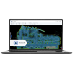
Capturing data is only the beginning. What truly matters is how you process and extract valuable insights from it. That’s where a robust software platform like FARO Connect comes in—offering fast data processing and a suite of automated, pre-built workflows such as change detection. With these tools, users unlock the full potential of their data to drive smarter decisions and better outcomes.
| Technical Specifications | |
|---|---|
| Scan Points per Second | 300,000 |
| Number of Sensors | 16 |
| Relative Accuracy | Up to 6 mm |
| Range | Up to 100 meters |
| Accessory Options | Enable users to capture data in a variety of ways |
One Handheld 3D Scanner — Endless Possibilities
- Real-Time Insight
With the ZEB Horizon RT, watch your scan come to life as you move. Track your progress live and see your point cloud form in real time—making scanning intuitive, efficient, and incredibly satisfying. - ZEB Vision: Bring Color to Your Scans
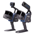
Quickly attach the ZEB Vision to capture stunning colorized data and 360° panoramic images in minutes. With crisp 4K resolution, it enhances the detail and realism of your point clouds, letting you explore your scanned environment like never before through immersive virtual navigation. - UAV Mount: Take Your Scanning to New Heights
Switch from walking to flying in moments with the drone-compatible ZEB Horizon RT and its quick-release mount. Compatible with DJI Matrice 300 and Freefly Alta series drones, it unlocks aerial mapping capabilities for hard-to-reach areas. - Vehicle Mount: Speed Up Data Collection
Mount your ZEB Horizon RT securely on a vehicle and scan while driving at speeds up to 30mph (48 km/h). Perfect for capturing data across small roads, town centers, and residential neighborhoods—covering more ground faster. - Cradle and Pole: Access the Toughest Spots
Go vertical or reach tight spaces effortlessly. The cradle lets you lower the scanner into underground shafts, manholes, silos, and other confined or hazardous zones. Meanwhile, the lightweight carbon fiber pole elevates your scan to inspect ceilings, stockpiles, bridges, and infrastructure in hard-to-reach areas.
Features
Below, you will find the main features of the product.
Effortless Environment Transitions
Move smoothly through spaces, capturing full datasets in a single pass. Whether inside or outside, stairwell to corridor, mobile LiDAR like the ZEB Horizon RT simplifies the workflow.
Speed Up Data Collection
Lightweight and easy to carry, this scanner lets you capture data quickly without multiple setups. Just power on, walk, scan, and return—simple and efficient.
Access Hard-to-Reach Spaces
Gain deeper insights by scanning difficult areas. The ZEB Horizon RT’s flexibility lets you safely lower scanners into vents or raise them into ceiling voids for comprehensive coverage.
Scan Anytime, Anywhere
Designed for ease, anyone can quickly map an area, making frequent rescans possible. Daily updates mean stakeholders get fresh data for smarter, faster decisions.
Enhance Data Capture
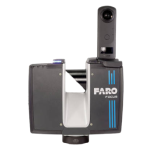
Pairing SLAM technology with LiDAR systems like the FARO Focus creates a powerful combo for capturing point cloud data that’s fast, accurate, and repeatable.
Extend Your Data’s Potential
After processing, export point clouds to third-party software to enhance analysis and seamlessly integrate with your existing workflows.
Applications
Discover the applications in which the product can be used.
Mining: Fast, Safe Data Capture for Modern Operations
Real Estate: Streamline Floorplan Creation
Forestry: Efficient LiDAR Mapping for Forest Management
Architecture, Engineering & Construction: Track Progress Continuously
Multimedia
Below you will find all available multimedia, including videos & images.
Testimonials
Read what our satisfied customers have to say.
Related Products
See related products from this manufacturer
Get a Quote
You can fill out the contact form below and one of our representatives will contact you shortly.