


TrueView GO 132S
Ready-Set-GO LiDAR & SLAM Technology
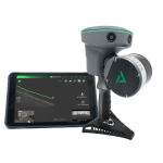
The TrueView GO 132S, by GeoCue, is an upgraded handheld mapping system for seamless indoor and outdoor reality capture and high-definition 3D mapping. This state-of-the-art device features 32 channels, three 5MP high-resolution RGB cameras, and a sophisticated 3D LiDAR & Imagery scanner, easily converting complex environments into precise digital twins.

The TrueView GO is equipped with a fourth-generation air dielectric GNSS antenna, offering RTK/PPK positioning accuracy, even in challenging environments. This high level of precision is further enhanced by the system’s advanced LiDAR and three HD cameras, which integrate GNSS RTK/PPK + laser + visual SLAM.
Equipped with a dedicated tablet and application enabling live view of the collected point cloud as you walk through your site to be collected, making sure you covered everything. The TrueView GO helps also to combine various data sets, enabling the creation of a digital twin of any project. This powerful tool allows you to merge data from drone and mobile mapping LiDAR systems, facilitating a seamless integration of both interior and exterior scans. The result is a dense, precise, and highly accurate As built environment of your entire project.
Effortless and Safe Scanning in Any Environment
- Operate with Weak or No GNSS: TrueView GO calculates accurate GNSS RTK/PPK point coordinates using LiDAR and Visual SLAM data, even in areas without satellite signals, enabling effective surveying in indoor spaces and urban canyons.
- Remote Measurement: The technology has the capability to scan inaccessible areas by collecting reference points without being on the exact point. The TrueView GO Tablet software calculates 3D coordinates in real-time, allowing precise measurements without physical access.
- Loop-Free Path Planning: Loop-Free Path Planning With GNSS RTK/PPK: There’s no need to walk in circles. TrueView GO’s SLAM technology eliminates the need for traditional loop closure and overlap, reducing the time and distance required for project completion by allowing flexible, efficient path planning when you have GNSS coverage.
Handheld LiDAR & Imagery processing workflow made simple
LP360 LAND is geospatial software designed for handheld LiDAR and imagery data from the TrueView GO. The LP360 software is preferred by many professionals due to its easy workflow to process raw data and its 4 synchronised pointcloud visualization windows (2D, 3D, profile and Immersive views). It also provides robust QA/QC tools which allows users to define custom issue lists, navigate data systematically, identify areas needing correction, and ensure the accuracy of geospatial data and deliverables. LP360 LAND offers a 3D point cloud processing solution, featuring capabilities such as SLAM, denoising, colorization, QA/QC, registration and classification. Leveraging both desktop and Cloud technologies, the software’s modules facilitate quick and seamless results for various applications, including 3D modeling, survey and topography maps, data classification, floor plan generation, volume calculation, and tree segmentation.
This state-of-the-art device features 32 channels, three 5MP high-resolution RGB cameras, and a sophisticated 3D LiDAR & Imagery scanner, easily converting complex environments into precise digital twins.
- High Quality GNSS
- x3 5 MP cameras (15 MP)
- Rotating, Survey-Grade, LiDAR Sensor
- Tablet & TVGO Software
TrueView GO 132S Traditional Basic
TrueView GO 132S Traditional Basic Purchase provides you with plans that include perpetual licensing of LP360 Land Basic software to efficiently manage and process your TrueView GO data within the user-friendly LP360 Viewer environment.
TrueView GO 132S Traditional Standard
TrueView GO 132S Traditional Standard Purchase provides you with plans that include perpetual licensing of LP360 Land Standard software to access the full suite of the LP360 features making it an essential upgrade for users seeking more efficiency in their workflow.
Extend Your Reach with TrueView GO Accessories
Take your TrueView GO to new heights—and depths—with our exclusive accessories. Venture into sewers, reach elevated areas, or scan on the move using a golf cart or ATV. These additions are designed to enhance your scanning capabilities like never before.
- TrueView GO 360 Photo Kit
The TrueView GO 360 Photo Kit enhances your handheld LiDAR by integrating an Insta360 camera with LP360 Land’s 360° photo viewer, allowing you to merge 360° imagery in your point cloud. Get a true “street view” of your data! - TrueView Suction Mount
Take your TrueView GO even further with the Suction Mount, designed to attach securely to vehicles like golf carts, ATVs, side-by-sides, cars, or trucks. Give your arms and legs a rest and effortlessly mount the TrueView GO to the front of a vehicle for extended scanning sessions. Note: For optimal data accuracy, maintain speeds no greater than 20 mph during data collection. - TrueView Pole Mount
Specifically engineered for the TrueView GO, the Pole Mount lets you safely scan hard-to-reach areas such as drainage systems, sewers, and elevated electrical or piping installations—all without putting yourself at risk. Easily adjustable, the Pole Mount can extend above your reach or lower the scanner below the surface, providing flexibility for various scanning scenarios.
Multimedia
Below you will find all available multimedia, including videos images.
Related Products
See related products from this manufacturer
Get a Quote
You can fill out the contact form below and one of our representatives will contact you shortly.