DJI GS Pro
Mission-Critical Flight Simplified
Enhance your drone operations with the DJI Ground Station Pro (DJI GS Pro) by DJI, an iPad app. Conduct automated flight missions, manage flight data on the cloud, and collaborate across projects to efficiently run your drone program.
Back up flight data securely on the cloud, giving missions higher reliability and accuracy. Reference historical information on flight missions, aircrafts, members, and flight logs so that workflows can be optimized.
Flight mission data is visible to all members of a project team, making data sharing easier. Members can view edits made by other team members, or duplicate flight parameter settings for new missions.
Virtual Fence
Virtual fence defines a specific area of flight and is useful in scenarios where some areas of a site are no-fly zones or if flight should only happen within one area, such as during manual pesticide spraying or flight. It is also useful in pilot training situations. As the aircraft approaches the virtual fence, it will brake and hover to ensure it stays within the flight area. The size and shape of the Virtual Fence is completely customizable. Set the maximum speed and altitude for the aircraft when flying inside Virtual Fences.
IMPORT KML/SHP Files
Increase your construction mapping efficiency by importing KML/SHP files into GS Pro. KML/SHP files, which contain important geographic information, can be imported into GS Pro via a PC or Mac wirelessly, or directly from within an iPad. After the geometries have been successfully imported, users can swipe left on the geometry list in the Map Panel, and GS Pro will automatically generate a flight mission according to the geometry field, helping users to conduct mapping with accuracy and ease.Mapping with GS Pro becomes even more flexible by adjusting waypoints. If GS Pro fails to generate a geometry similar to the target building or sets a flight route that’s not able to deliver a good result, users can still manually adjust the waypoints by dragging or add new ones to meet their needs.
Fleet and pilot Management
Manage pilots and drones through the creation of teams, making missions more coordinated. Designate roles with different permissions to improve communication. Track the status of aircrafts to make proactive purchasing and maintenance decisions.
| Agent | Administrator | Member | |
|---|---|---|---|
| View all projects | ✔️ | ✔️ | Only projects they are in |
| View all flight logs | ✔️ | ✔️ | Only flight logs they created |
| View all members | ✔️ | ✔️ | – |
| Add/delete members | ✔️ | ✔️ | – |
| Modify member permissions | ✔️ | – | – |
| Purchase and renew software license | ✔️ | – | – |
Project Management
Improve the efficiency of your drone operations by tracking individual projects and streamlining the project management process. Access to project status can be granted on a per project basis so that critical data is only available to the relevant members.
| Project Manager | Operator | |
|---|---|---|
| Manage personal flight missions | ✔️ | ✔️ |
| View flight missions of other members | ✔️ | ✔️ |
| Copy mission settings of other members | ✔️ | ✔️ |
| Archive and unarchive projects | ✔️ | – |
| Manage project members | ✔️ | – |
| View historical mission activities | ✔️ | – |
| Set flight parameters from a particular mission as default settings | ✔️ | – |
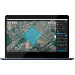
3D Map Area
- Custom Flight Zones:
GS Pro automatically generates efficient flight paths after the user has set their required flight zone and camera parameters. The aircraft will then follow this route throughout its mission. The image data captured during these flights can be input into 3D reconstruction software to generate 3D maps, while the mission itself can be saved for re-use. Draw a custom polygonal flight zone on-screen or fly around the zone to mark zone boundaries using the aircraft’s GPS coordinates. - Adjust Parameters:
Adjust parameters including photo overlap ratio, altitude, shooting angle — parallel or vertical to the main flight path — course angle, and margin. Capture images at equal time intervals, equal distance intervals, or to hover at a waypoint during capture. - Inside Mode and Scan Mode:
Two Flight Course Modes are available: Inside Mode, in which the aircraft follows an automatically generated routed within the chosen area, and Scan Mode which provides the fastest route to cover a designated area. - Flight Plan Overlap Ratio:
To achieve better 3D reconstruction, the default photo overlap is optimized for a range of supported cameras. It can also be independently adjusted.
Tap and Go Waypoint Flight
- Multiple Waypoints:
Up to 99 waypoints are available, depending on the needs of each flight. - Adjustable Parameters:
The altitude, speed, gimbal pitch and aircraft rotation (clockwise or counterclockwise) at each waypoint can be pre-defined. - Various Waypoint Actions:
Each waypoint can have up to 15 consecutive actions, including aircraft rotation, gimbal pitch, start/stop recording, photo capture, and hover. - Set End-Mission Actions:
After the aircraft finishes its flight mission, it can be set to Return to Home, Hover, or Land.
Features
Below, you will find the main features of the product.
3D Map POI
Generate detailed maps of tall structures using 3D Map POI. Simply choose the subject and set a distance between it and the aircraft. DJI GS Pro will then provide relevant parameters including speed and time required to circuit the structure. Images captured can be exported into 3D reconstruction software to create accurate 3D models of the entire building.
Industrial Applications
DJI GS Pro is a powerful, convenient and easy to use tool. With just a few taps on an iPad, complex flight routes can be created, giving critical missions added accuracy and reliability. DJI GS Pro is an indispensable tool that is capable of dramatically increasing efficiency in a wide range of industries.
PhotoMap
The newly-added Photomap function helps users efficiently create aerial photograph-based maps. After users complete an aerial photography mission in the desired area and import the photos into GS Pro, the software will automatically create a composite photo of the area that users can adjust as needed.
Multimedia
Below you will find all available multimedia, including videos & images.
Related Products
See related products from this manufacturer


Get a Quote
You can fill out the contact form below and one of our representatives will contact you shortly.