


RADAN Software
The Most Advanced GPR Data Processing Software
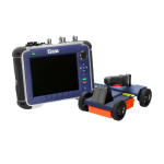
RADAN Software by GSSI, is a state-of-the-art post-processing software. With its modular design, this program allows users to select the processing functions that best suit their professional needs. RADAN is Windows™ based, providing a familiar and easy-to-use environment for all levels of experience.
GSSI offers several optional software packages that allow users to process the data from its products for further interpretation. Radan software is a post-processing software package designed to process, display and document 2D and 3D data collected with GSSI ground radars. The software features smart menu and data screens with clear data visualization for easy interpretation and enhanced post-processing capabilities.
Data Processing and Annotation:
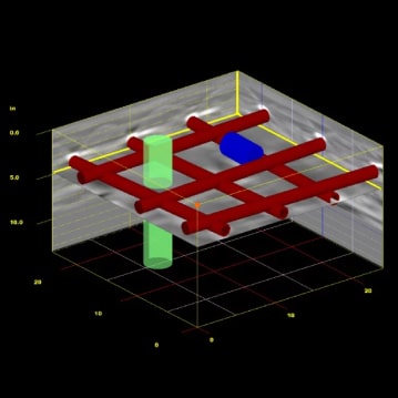
- Processing of 3D datasets
- Import 3D targets – change the size and color of the targets
- Virtual 3D drilling
- Multiple color table and transformation options
- Windows ® 7 based work environment
Visualization:
- Background removal filters
- Data Migration (focusing)
- Adjustable contrast
- Use of natural terrain for accurate depth calculations
Reference Building:
- Generate Report – export report using MSExcel
- Copy data images for use in third party software for documentation purposes
- Adding targets such as colored circles and exporting target information in Excel format
- Save data images to JPG files
- Print to all printers supported by Windows
RADAN Benefits
- Familiar, easy-to-use Windows based system
- Easy Processing feature- automated processing wizard that recommends the best processes for cleaning up and improving data
- On-screen help features
- Application specific modules
- Add company logo with customizable report print out
Advanced Features
- Performance – multiple software threads are able to run in parallel, enabling higher levels of software performance and speed
- Enhanced, easy-to-use 3D capabilities
- Batch Processing – significant enhancements to speed repetitive tasks such as processing large data sets
- GPS and 3D Integration – software will allow easy integration of 3D data sets that have been collected with GPS positioning information, allowing interpolation of non-parallel lines
- AutoCAD Target output – seamless output of interpreted data results to AutoCAD
- Ideal for single- or multi-channel data processing
Applications
Discover the applications in which the product can be used.
3D Module: The Next Generation of 3D Mapping
The 3D module also shows multiple interactive views of 2D and 3D data simultaneously and to create shapes (pipes, drums, lines, etc.) in the GPR data, which can then be exported for integration with CAD drawings. This way, the data can be presented to the client in a familiar, easy to understand format. These 3D options provide users with unparalleled data interpretation and presentation capabilities.
BridgeScan Module: Map Bridge Deck Deterioration
RoadScan Module: Conduct Pavement Layer Analysis
This software module includes automatic and interactive layer interpretation, automatic and interactive pavement thickness and provides output of signal and position information to an ASCII database for roadway condition assessment.
StructureScan Module: Interpret Targets
This software module includes automatic and interactive layer interpretation, automatic and interactive pavement thickness and provides output of signal and position information to an ASCII database for roadway condition assessment.
Related Products
See related products from this manufacturer
Get a Quote
You can fill out the contact form below and one of our representatives will contact you shortly.