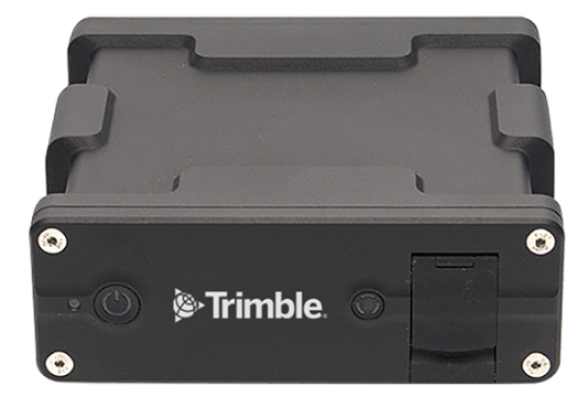
Trimble Applanix POS AV
GNSS/INS systems for aerial mapping
The POS AV system, by Applanix, is designed for direct georeferencing of airborne sensor data, integrating precision GNSS with inertial technology. It enhances the efficiency, effectiveness and economy of geospatial projects. Supported by industry expertise and innovation, the Applanix POS AV is ideal for aerial cameras, scanning lasers, imaging sensors, synthetic aperture radar and LIDAR technology.
Elevate your aerial survey projects with Trimble Applanix POS AV. Experience unparalleled precision with our compact, rugged GNSS/INS system. Use it to trust your position anywhere in the air.
Applanix POS AV is a compact, fully integrated turnkey position and orientation system (GNSS + INS) that leverages advanced inertial technology to deliver stable, reliable and repeatable positioning solutions for airborne vehicle applications.
Trimble Applanix POS AV benefits,
- Provides an accurate real-time and post-mission solution for all motion variables, including sensor-specific exterior orientation (EO) parameters using Direct Georeferencing
- Allows for single-stereo model mapping and single-photo orthorectification using an existing digital elevation model
- Streamlines and automates the data workflow and quality control processes
- Easily integrated with digital cameras, film cameras, LIDAR systems, SAR systems and digital scanners
- Ideally suited to inhospitable environments and rapid response applications where ground control is not available
- Eliminates the requirement for aerotriangulation and a complete ground control survey (often only checkpoints for quality control are needed)
- Improves productivity in traditional aerial mapping applications, which translates into operational time and cost savings, with increased accuracy
Product Specifications
- High-performance, survey-grade multi-frequency GNSS receiver with embedded Trimble CenterPoint RTX correction services
- Compact, rugged construction with low power consumption, full in-air alignment support and auto-log functions
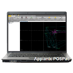
- Applanix POSPac MMS software for comprehensive post-processing, including POSPac post-processed CenterPoint RTX for mapping without base stations and IMU boresight calibration
POS AV performance summaries: SmartBase post processed
Absolute accuracy specifications (RMS) typical performance. Actual results are dependent upon satellite configuration, atmospheric conditions and other environmental effects
| Product | Product Details |
|---|---|
| POS AV 310 | X,Y Position: 0.02 m, Z Position: 0.05 m, Velocity: 0.010 m/s, Roll & Pitch: 0.015°, True Heading: 0.035° |
| POS AV 510 | X,Y Position: 0.02 m, Z Position: 0.05 m, Velocity: 0.005 m/s, Roll & Pitch: 0.005°, True Heading: 0.010° |
| POS AV 610 | X,Y Position: 0.02 m, Z Position: 0.05 m, Velocity: 0.005 m/s, Roll & Pitch: 0.0025°, True Heading: 0.005° |
| POS AVX 210 | X,Y Position: 0.02 m, Z Position: 0.05 m, Velocity: 0.015 m/s, Roll & Pitch: 0.025°, True Heading: 0.08° |
Features
- Seamlessly integrates with Applanix POSPac MMS, the industry-leading software for Direct Georeferencing of mobile mapping sensors using GNSS and inertial technology, offering advanced post-processing capabilities
- Applanix POSPac MMS post-processing software with POSPac Post-processed Centerpoint RTX for cm level accuracy without base stations, POSPac photogrammetry tools option for or EO generation, IMU boresight calibration and quality control, POSPac LIDAR QC Tools option for IMU boresight calibration and trajectory adjustment
Features
Below, you will find the main features of the product.
High-performance Antenna
High-performance, low profile FAA certified GNSS L-Band antenna
High-performance Receiver
High-performance, survey-grade multi-frequency GNSS receiver
Stabilized Mounts
Real-time leveling and yaw drift correction of stabilized mounts
Internal Data
Internal data logging for redundancy
In-air Alignment
Full in-air alignment support
Commercial Grade IMU
Commercial grade IMUs for ease of export
Rugged Construction
Compact, low-power, lightweight, rugged construction
Airborne
Meets airborne environmental operational requirements
USB Port
Removable USB data logging with unique sealed port
Correction Service
Optional Trimble CenterPoint RTX™ correction service for cm level real-time positioning and georeferencing
Simple to Use
Simple to use and operate with auto-log and auto-start functions
Multiple Interfaces
Multiple interfaces for simple integration with imaging sensors
Related Products
See related products from this manufacturer


Get a Quote
You can fill out the contact form below and one of our representatives will contact you shortly.